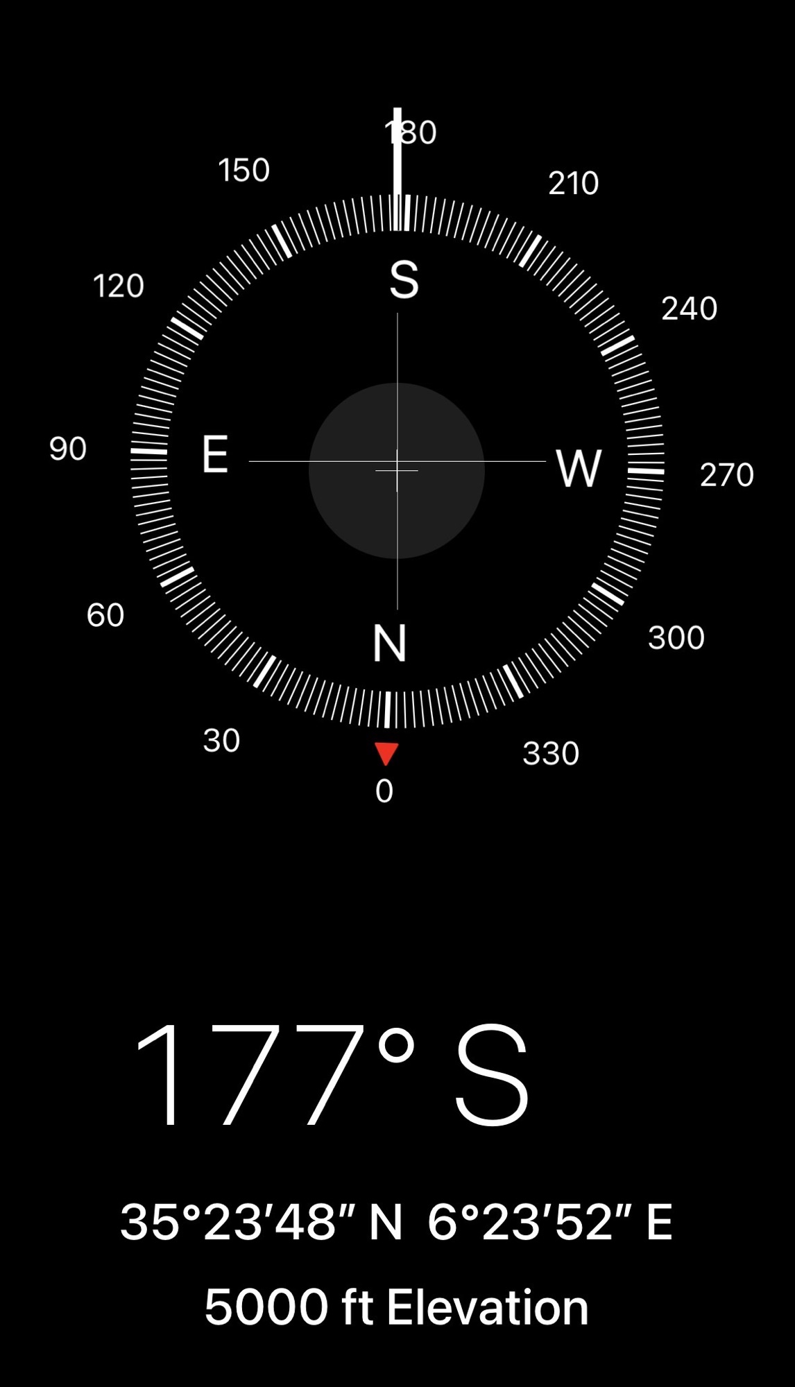
3 April 2026
We depart Constantine for our 170-mile drive into the northern Sahara Desert. The route looks curvy as it winds itself southwesterly on state routes. We drive among the cliffs and low mountain ranges of the Batna Province. These represent a natural geographical break through the Atlas Mountains.

By the time we reached Biskra, the Sahara had fully committed itself to its monochrome phase. The northern Sahara doesn’t believe in variety. The scenery remains stubbornly the same—brown on brown on brown.
Occasionally, a palm tree pops up like a visual exclamation point. Homes and villages seem less constructed than extruded from the earth, made of red bricks, maybe some mud, straw, water, and whatever else the desert had on hand. Including, I suspect, the business end of a camel.
Madghacen Royal Mausoleum

Located in what seems an isolated plain near Boumia, this mausoleum represents one of the oldest surviving royal tombs in North Africa and dates to approximately the 4th–3rd century BCE. Built by the Numidian Berber kingdom, the monument reflects the power and early state formation of Amazigh rulers before Roman domination.
The structure is a large circular stone tumulus about 60 feet tall and 193 feet in diameter and surrounded by sixty columns.
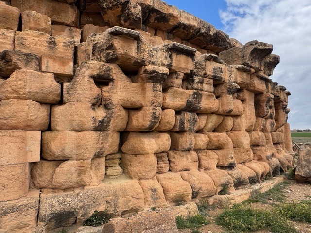
Influenced by Greek Doric architecture, it indicates an early cultural contact between North Africa and the Mediterranean world.
Traditionally associated with the legendary king Madghis, considered an ancestor of several Berber tribes, the mausoleum represents an important symbol of pre-Islamic Algerian history. Its architectural style later inspired other royal tombs in the region, demonstrating the continuity of indigenous funerary traditions.
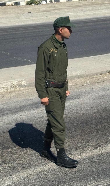
Wo-Wo Brotherhood – Green Guard
Driving deeper toward Biskra, the Sahara doubled down on its minimalist aesthetic. Villages appeared to be molded directly from the earth, so well camouflaged they looked like the desert had simply grown houses. Everything blends in perfectly, as if Desert Bylaws issued firm design rules and everyone politely followed them.
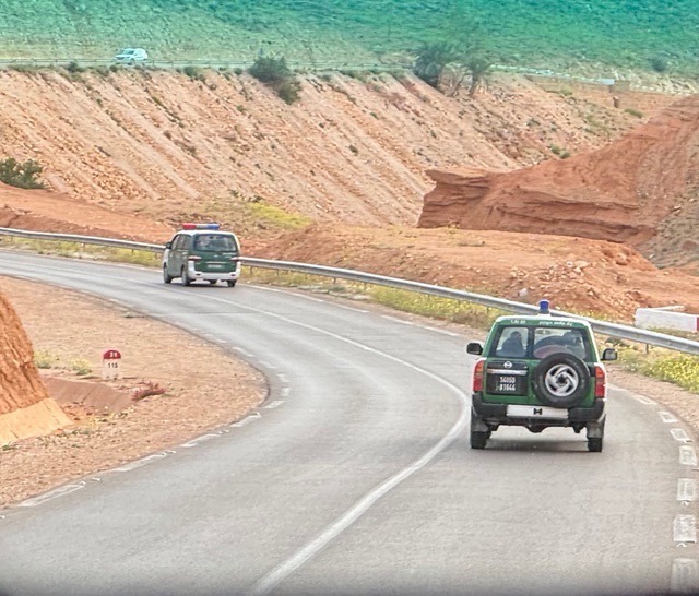
We pass from the province of Batna into Biskra and the beginnings of the Saharan Atlas chain. Our location brings on our Green Guard, the little men in the green suits.
The Sahara covers vast distances with limited infrastructure and police checkpoints help authorities track visitors’ movements, coordinate emergency assistance, and ensure travelers stay on safe routes. Escorts may also help manage long remote stretches without services and maintain communication between regions. The presence of police or gendarmes becomes routine, friendly, and intended to provide reassurance rather than restrict our movement.
The practice developed during the 1992-1999 Civil War when some tourists were killed.
The Algerian Civil War (roughly 1991–2002), known as the “Black Decade,” developed into a brutal conflict primarily fought between the Algerian Government/Military and various Islamist rebel groups. The conflict followed a military coup that cancelled elections which the Islamic Salvation Front (FIS) party was poised to win. It resulted in estimated deaths ranging from 150,000–200,000 people. The conflict also caused about 15,000–20,000 disappearances and widespread displacement.
This Black Decade ended not through a decisive military victory, but via a combination of military crackdown, the fragmentation of armed groups, and a political process focused on amnesty and national reconciliation. The Charter for Peace and National Reconciliation of 2005 allowed most fighters to return to civilian life.
After peace returned, authorities decided to continue this practice and closely monitor travel in sparsely populated southern areas. Although the country is now far more stable, the escort system remains as a precaution. Agreed, it does not look good killing the tourists. As my nephew Don quoted from Jurassic Park:
Yeah, but John, if The Pirates of the Caribbean breaks down, the pirates don’t eat the tourists….
The policy reflects Algeria’s strong emphasis on safeguarding tourism while balancing the logistical challenges of traveling through one of the world’s largest deserts. It is simply part of the travel experience when entering the deep Sahara.
Lights flashing, siren wo-wooing as we enter intersections or roundabouts, we zip our way to the restaurant, Roman ruins, or hotel. Locals seem to hardly notice.
Just Like That – Scenery Explodes
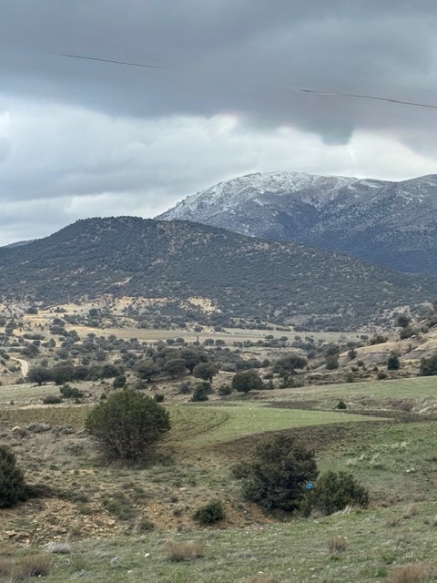
Aurès Mountains
The Aurès Mountains are part of the northern Saharan Atlas chain, a rugged and historically important range with Batna Province, often described as the heart or capital of the Aurès. Known for its dramatic scenery, this includes lots of steep ridges, deep gorges, and high plateaus. The region also reflects a strong Amazigh (Chaoui) cultural identity and long history of resistance, from Roman times through the Algerian War of Independence and Civil War.
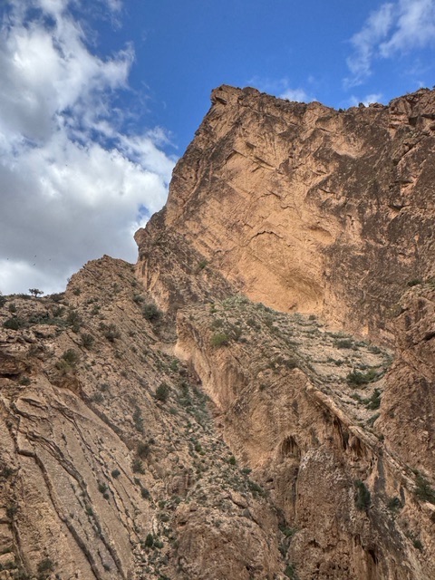
Within the Aurès, the Belezma range stands out for its forested slopes and ecological richness. Belezma National Park protects significant stands of Aleppo Pine and rare Atlas Cedar, creating an unexpected contrast to the surrounding semi-arid landscapes. The range includes Djebel Chélia, the highest peak in the Aurès, rising to roughly 7,600 feet. Winters can be cold, with snowfall common at higher elevations. Meanwhile, summers are generally dry and mild compared to the lowlands.
Remote valleys, traditional villages, and Roman archaeological sites dot the valley. Thus, the landscape becomes a striking blend of harsh mountain terrain, biodiversity, and deep historical layers. Our first stop of the day represents one of those stunning sites.
Roman ruins of Timgad
The countryside consists of mostly flat landscapes and green fields of grain mixed with wadis and gorges. Mountains loom in the distance. Many with snow capping their peaks. The constant wind negates whatever effort the sun makes to warm things up.
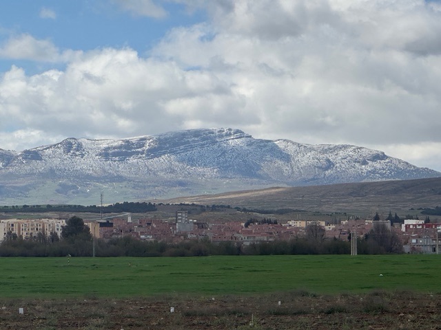
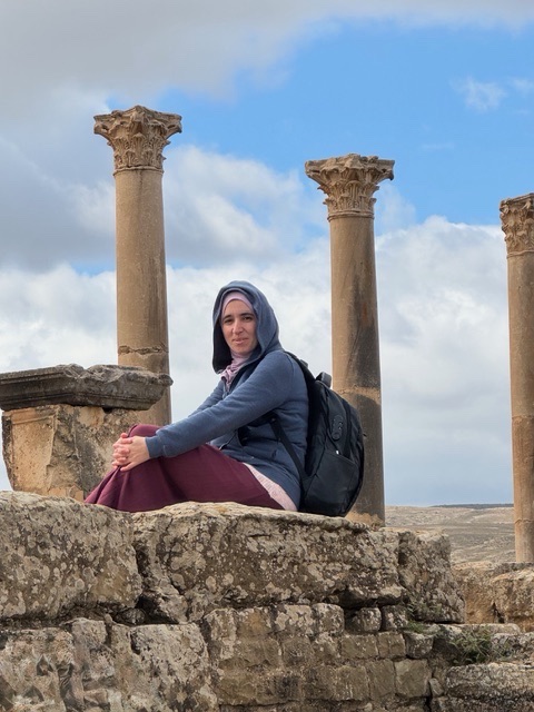
We continue our drive into the mountains along N87. The road appears to straighten a bit as we descend the mountains and once again face the barren desert landscape. Reaching the outskirts of Timgad, we stop at our next destination: the UNESCO site of ancient Roman ruins.
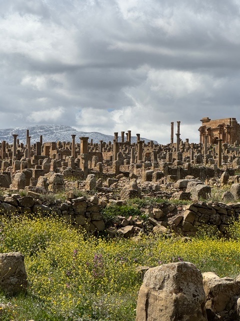
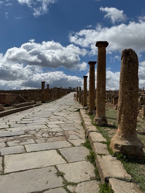
Timgad is one of the best-preserved Roman cities in North Africa and feels almost like a classical city not only frozen in place but freezing. Emperor Trajan founded it a military colony for retired legionaries around 100 CE. I see lots and lots of rocks and pillars. High mountains capped with snow surround the Roman city and freezing cold winds sweep across Timgad. I hardly think of this as a site for retirement, Roman or otherwise.
Builders laid out a precise grid, still clearly visible today. Walking through the site, which includes over 200 acres in which resided 15,000 Romans, I can easily follow the main streets, Cardo Maximus and Decumanus Maximus, intersecting at the forum. It demonstrates a strong sense of how ordered and planned Roman urban life was.
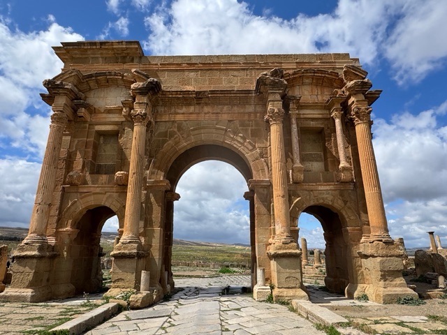
Within the site can be seen remains of the large forum. A library once held thousands of scrolls. There remain the sites of a Curia or council house, fountains, baths and latrines. The most iconic structure is Trajan’s Arch, which still stands at the western entrance to the city and frames views of the Aurès Mountains beyond.
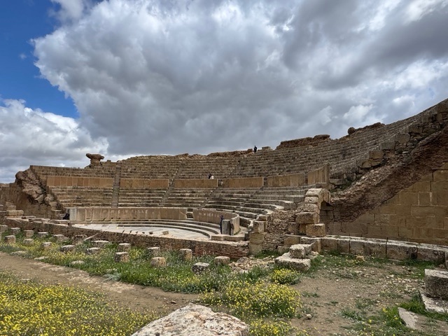
There is also a well-preserved theater carved into a hillside that once seated about 3,500 spectators. It remains in use for performances. Surrounded by open steppe and mountains, Timgad feels monumental yet easy to imagine daily life along its streets nearly two thousand years ago.
I see rocks, looks like a camel head. No birds fly, common sense tells them to hunker down. For me, my interests exponentially drop the colder I get. And I am really cold as winds buffets and blasts.
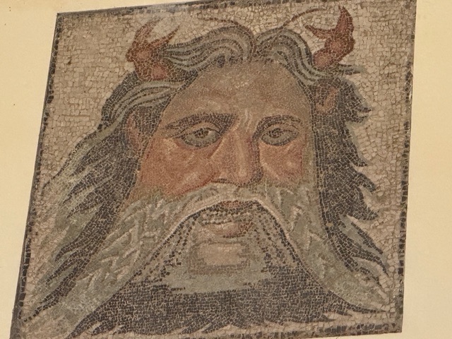
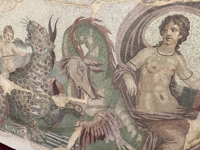
Timgad Museum
After lunch, we return to the small Timgad Archeological Museum. Mosaics of all sizes are displayed. Most were excavated from this site. I believe the mosaics here and those previously seen in Algeria represent some of the largest and finest displayed anywhere.
Balconies of El Ghoufi
These cliffs are considered one of Algeria’s most striking landscapes: a dramatic line of ancient stone villages clinging to the sheer cliffs of the Oued Abiod Canyon. From a distance, houses appear stacked one above another.They follow the natural curve of the rock face, as if the cliff itself decided to become a village. The view looks out over a deep gorge carved by water over millennia. Palms and cultivated patches far below contrast sharply with the pale limestone walls.
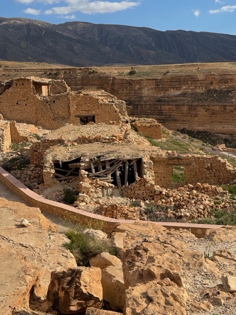
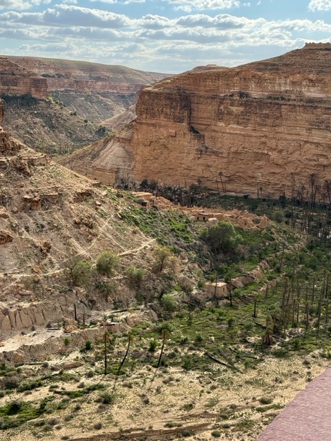
The site dates back at least a thousand years, created by the Chaoui Amazigh communities who settled here for protection, water access, and agricultural survival. The Chaoui Amazigh are an Indigenous Berber people native to the Aurès Mountains. Their presence in the region dates back thousands of years, long before Roman, Arab, or Ottoman rule. They are among the oldest continuous inhabitants of North Africa. The name Chaoui refers both to the people and to their language, Tachawit, a Berber (Amazigh) language still spoken today.
Historically, the Chaoui were mountain farmers, herders, and defenders of this difficult terrain. They shaped a culture built around self-reliance and close ties to land and clan. They practiced terrace agriculture, raised livestock, and developed sophisticated water-management systems to survive in a harsh environment of cold winters and dry summers. Their villages were often fortified or placed in inaccessible locations, such as El Ghoufi. This reflected both environmental necessity and the need for protection.
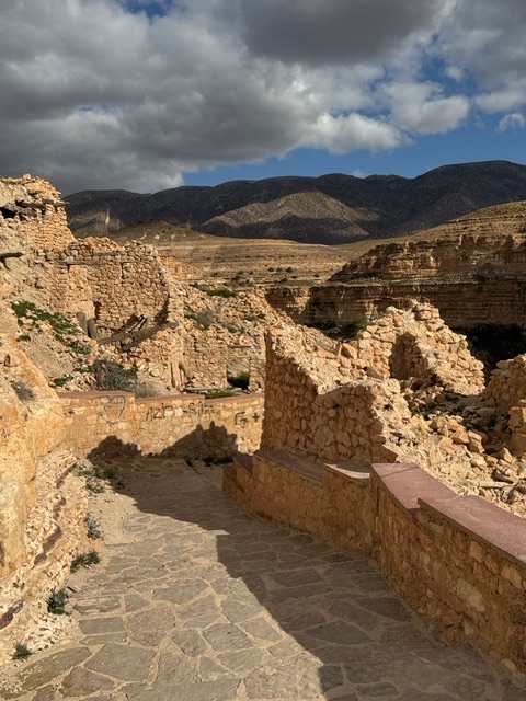
Builders used local stone, mud, and lime, carving foundations directly into the cliff and terracing the slopes for crops. The layout reflects both environmental adaptation and social organization, with narrow paths, shared walls, and gravity-fed irrigation systems drawing water from the wadi below.
The Aurès became famous as a center of resistance. The Chaoui fought Roman occupation, later resisted imperial powers, and played a decisive role in launching the Algerian War of Independence in 1954. Today, many of the old villages lie partially abandoned, which gives El Ghoufi a haunting, timeless atmosphere. It became less a ruin than a landscape where architecture and geology were inseparable. Regardless, Chaoui identity remains strong.
Biskra
Biskra acts as a gateway city where northern Algeria gives way to the Sahara in earnest. It appears greener than I expected, wrapped in one of the country’s largest date-palm oasis, yet undeniably desert at heart. I’m told they haven’t had water in the river for three years. The town itself appears busy and practical rather than picturesque.
I see low-rise buildings, markets humming with daily trade, cafés spilling into the shade (filled entirely of men). A constant movement of people travel north or deeper south. Historically, Biskra was a Roman outpost and later a caravan hub, and it still carries that sense of being a stopping point rather than a final destination. Huge semis fill the highways.
Several gardens break the monotony of desert, including the Aqua Palm Biskra, an immense water park. There is a university, several mosques and a few museums. And, surprisingly, an International Airport. None of which, after our long drive, we visit. Biskra, like those travelers for centuries before us, acts only as an overnight stopping point in our journey.

I Love Biskra sign in front of hotel. Sorry, NOT.
Overnight Lodging
We lodge overnight at the Hotel Maurice Laban, a rather dumpy, mothball-smelling 4-star, 4-storey hotel located in the center of the city. Our welcome consists of a plate of dates and milk. I pass. Dinner in the hotel is buffet. Mostly cold, tired and tasteless.
0 Comments